19 November 2026 · Terravision · 6 min read
EMIT vs ASTER vs Sentinel-2 for alteration mapping
People often ask which satellite we use. The honest answer is all three, because each is good at something the others are bad at. Here's how we think about them when we're mapping hydrothermal alteration, which in practice means looking for clays, sulphates and iron oxides at the surface.
The idea in one paragraph
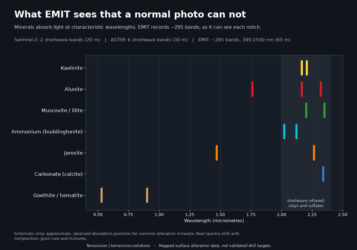
Minerals absorb sunlight at particular wavelengths. Kaolinite has a doublet near 2.16 and 2.20 micrometres, alunite near 1.76 and 2.17, muscovite near 2.20 and 2.35. A sensor that sees those wavelengths finely enough can tell the minerals apart. A sensor that only has a couple of coarse bands there can say "something clay-like is here" and not much more.
EMIT: the one that identifies minerals
NASA's EMIT instrument sits on the International Space Station and records about 285 bands between 380 and 2,500 nanometres at roughly 60 metres per pixel. That's an imaging spectrometer, and it's the first time that kind of data has been freely available at scale. It can separate kaolinite from alunite from muscovite from ammonium-bearing clays. That's the difference between "altered ground" and "advanced argillic alteration with alunite here and sericite there".
What it can't do: cover everywhere regularly. The ISS orbit limits it to latitudes roughly within 52 degrees, and EMIT acquires scenes on a targeting schedule rather than imaging the whole planet on a loop. Some places have a dozen clear looks and others have one or none. At 60 metres, pixels mix rock, soil and plants, so a narrow alteration zone can be diluted. We treat a mineral as confirmed only if it shows up in repeat looks, and we check how well independent halves of the data agree.
ASTER: the old reliable, with a catch
ASTER, on NASA's Terra satellite, has six shortwave-infrared bands at 30 metres, which made it the workhorse of satellite alteration mapping for two decades. Band ratios pick out clays, carbonates and, with the thermal bands at 90 metres, silica-rich rocks. It remains a good source for those.
The catch is that the shortwave-infrared detectors stopped working in April 2008. If you need ASTER SWIR, you're using archive scenes from before that date; there's no fresh data. For geology that hasn't changed, that's fine, but it means cloud-free coverage over your area might be patchy and you can't order a new look. The thermal bands still work. We use ASTER as a second opinion on clay, carbonate and silica, not as the headline.
Sentinel-2: fresh, frequent and coarse in the right place
ESA's Sentinel-2 satellites image almost the whole land surface every few days at 10 to 20 metres, with 13 bands. For alteration there are two that matter, shortwave infrared near 1.61 and 2.19 micrometres, and its visible and near-infrared bands are good at iron oxides. The ratio of the two SWIR bands gives a decent broad clay signal.
It can't separate one clay from another, and it can't see the alunite or jarosite features that sit where Sentinel-2 has no bands. What it does well is give you recent, fine-scale, cloud-screened composites anywhere, which is perfect for iron staining and for placing the coarser mineral maps against real ground features. For many places outside EMIT's coverage, it's the only option.
How we use them together
| Sensor | Ground size | We use it for |
|---|---|---|
| EMIT | 60 m | Naming the minerals, and confidence from repeat looks |
| ASTER (archive) | 30 m | Second opinion on clay, carbonate, silica |
| Sentinel-2 | 10–20 m | Iron oxides, fine detail, coverage everywhere |
We also map faults and lineaments from high-resolution terrain data. Where the sensors agree, we take that more seriously than any one of them on its own.
What none of them can do
All three see the top few micrometres of the surface. Cover, such as alluvium, soil, dense vegetation or desert varnish, hides alteration beneath it. A strong clay anomaly isn't a drill target, and plenty of altered ground is barren. We'd call these maps a way of deciding where to spend field days. Anyone who tells you a satellite can pick drill holes from orbit is selling something.
Try it on ground you know
We've put the approach into a finished map pack for Goldfield and Cuprite in Nevada, a dry, well-exposed district where the answer is already largely known. It has twelve EMIT mineral groups, Sentinel-2 and ASTER indices, known mines, claims and land status, all at preview resolution on the page so you can judge it first. See the Goldfield–Cuprite pack, or tell us about your own area.
Mapped surface alteration layers, not drill targets.