Terravision / Services
What we can do for a project.
The core of the work is satellite alteration mapping and terrain structure, delivered as files you can open in a GIS. Around that we offer ready-made packs, exclusive open-ground targets, and further services with public prices in US dollars. An introductory rate applies to a new client's first project on several of those services until 31 March 2027.
Mining exploration
Alteration and structure over a project area you name. From $950. Delivery in 48 hours.
Custom mappingGeothermal exploration
Surface minerals and faults for geothermal ground, with the same turnaround and rates.
Ready-madeMap packs
Finished districts in Nevada, Utah and New South Wales, as instant downloads.
Exclusive targetsUnclaimed alteration targets
Open BLM ground in Nevada and Utah, each sold to one buyer. From $695.
$2,900 per basin · intro $1,950Lithium brine and clay screening
Surface clays, carbonates and evaporites, with a finished pack for Clayton Valley.
$1,500 per project · intro $995Due-diligence reports
An independent check of surface alteration, structure and tenure context. Three working days.
Baseline $2,900 · intro $1,950 · then $450 a monthGeothermal InSAR monitoring
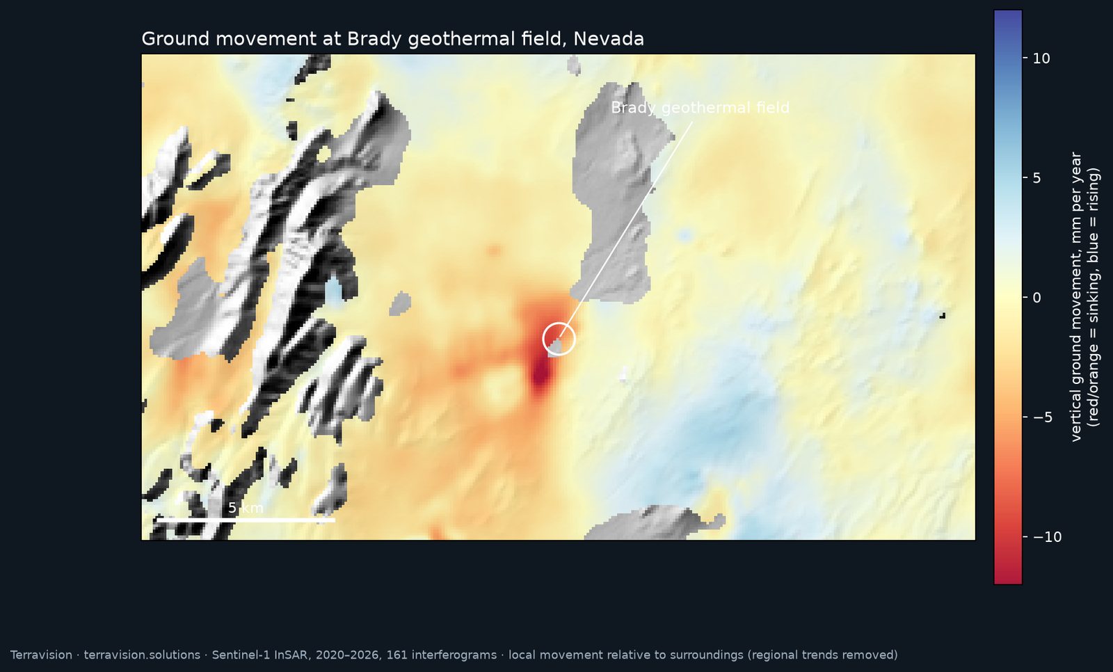
Ground-deformation from satellite radar, as a baseline or a monthly series, with a Brady pilot to look at.
$95 a month per districtClaim and tenure alerts
A watch on nearby ground that opens or is staked, starting with US BLM.
$2,900 per site · intro $1,950Mine-waste and environmental mapping
Iron oxide and acid-drainage minerals from EMIT, for closure and ESG teams.
$650 per areaPre-fieldwork site packs
Access, slope, terrain and targets in one PDF, before a field programme.
From $4,500 · intro $2,9003D seismic interpretation
Fault and horizon picking on your 3D volume, with a worked public-data demonstration.
Lithium brine and clay screening
EMIT can map surface clays, carbonates, gypsum and other evaporite minerals that often sit in and around lithium-bearing basins. It cannot see dissolved lithium in brine at depth, and a clay pixel is not a grade. The work is a way of seeing which parts of a basin have the surface mineralogy you care about, and which already sit on claimed or restricted land.
A finished example is the Clayton Valley map pack, which you can download now. Custom screening of another basin is $2,900 per basin area, or $1,950 for a new client's first project until 31 March 2027. There is a longer note on what EMIT can and cannot see at Clayton Valley.
All prices in US dollars. The Clayton pack remains $295 for a single-user licence, as an instant download.
Satellite due-diligence reports
For investors, royalty companies and project evaluators who want an independent look at a property before committing funds. We map surface alteration and structure over the project and its immediate surroundings, place that against public tenure and land-status where the records exist, and write a short report: what the sensors show, what they do not, and what should be checked on the ground.
This is not a resource estimate, not a valuation and not investment advice. We have no hidden interest in the ground we are asked to review. The check is $1,500 per project, or $995 for a new client's first project until 31 March 2027, and is delivered within three working days of a confirmed boundary.
Geothermal ground-deformation monitoring (InSAR)
A satellite-radar service for geothermal fields and similar ground, offered as a one-off baseline or as monthly monitoring. We use Sentinel-1, and NISAR as that coverage becomes usable. The aim is to see how the ground has moved, not to map minerals.
A baseline deformation report is $2,900, or $1,950 for a new client's first project until 31 March 2027. Ongoing monitoring is $450 a month after a baseline. We pitch it as a baseline plus monitoring: a first look at how the ground has behaved over the archive, then regular updates, not millimetre-precise mapping.
As a worked example we ran a pilot on the Brady geothermal field in Nevada. Free Sentinel-1 data from 2020 to 2026 picked out the known production-related subsidence bowl at about 8 to 14 mm a year, consistent with published work on the field, with a few mm a year of noise. See the Brady pilot, with the map and time series →
All prices in US dollars. One pilot is an example, not a guarantee for your field. We will say honestly whether the archive looks usable.
Claim and tenure monitoring
A watch on ground you care about: alerts when nearby parcels appear to open, or when new claims are recorded against public registers. We are starting with US BLM data. This is a desktop watch, not a title search, and it will only be as current as the public feeds allow. We will not claim to catch every filing the moment it is made.
The service is $95 a month per district, in US dollars.
Mine-waste and environmental mapping
Iron oxide and acid-drainage minerals — among them jarosite, goethite and hematite — can be mapped from EMIT at the surface. For closure and ESG teams, that is a way of seeing where those minerals sit around historic workings, dumps and drainages, and how the pattern compares with earlier looks when the archive allows.
It is still a 60 m surface product. It does not replace site sampling, water chemistry or a formal environmental assessment. A site is $2,900, or $1,950 for a new client's first project until 31 March 2027, in US dollars.
Pre-fieldwork site packs
A single PDF, and the underlying files, that pull together access, slope, terrain and the target or alteration layers before a field programme. The idea is that a small team can brief from one document rather than a pile of GIS layers. Contents are agreed for the job; we will not pad a pack with layers that do not help on that ground.
A pack is $650 per area, in US dollars.
3D seismic interpretation
Fault and horizon picking on client 3D seismic volumes. This is work on data you already hold, not a substitute for a survey. To show what the deliverables look like, we ran the workflow on a public dataset, the Parihaka 3D survey from offshore New Zealand. It is a demonstration, not client work. See the 3D seismic demonstration →
Work is quoted on the size of the volume, from $4,500, or $2,900 for a new client's first volume until 31 March 2027, in US dollars. If you have a volume and a question, send them and we will say whether we are the right people for it.
Tell us what you need.
A rough location or a short brief is enough to start. We reply to every enquiry, usually the same day, and we will say if a service is not a good fit.